I find it hard to believe, but ten years ago today I was finishing preparations for my last of what seemed to have been countless business trips I had made while I was involved in the RAMOS (Russian-American Observation Satellites) program. After devoting about half of my professional career up to that point in time involved to one degree or another as a member of the US science team on this joint Russian-American space project, RAMOS was quickly winding down after it had been unilaterally cancelled by its American partner despite over a decade of work by a dedicated team of American and Russian engineers and scientists with the expenditure of $120 million.
What is almost as difficult to believe is that even after all this time, a history of this groundbreaking international cooperative project has yet to be written. And except for the program’s participants and a relatively small handful of scholars involved in studying esoteric aspects of international cooperation, RAMOS seems to have been largely forgotten today. There has even been at least one instance that has come to our team’s attention recently of a group hoping to start a new cooperative project with the Russians being genuinely surprised to learn that a joint program like RAMOS even existed!
I feel that I am hardly in a position at this point to present a detailed programmatic history of RAMOS with all of its diplomatic, political and bureaucratic twists and turns. Despite this, I feel it is time to attempt to begin to provide an overview of the RAMOS program, its objectives, the science it was to produce as well as the results from cooperative experiments performed with our Russian partners in support of RAMOS at least from the perspective of one scientist involved in the program.

The author, Andrew LePage, in his younger days (far right) during a joint Russian-American meeting at Astrophysica in Moscow in September 1999. The head of Astrophysica’s RAMOS team was V. Abramov (far left). (A.J. LePage)
The Origins of RAMOS
Since the first flights of the experimental American MIDAS (Missile Defense Alarm System) early warning satellite series starting in 1960, it was recognized that one of the major issues limiting the ability of early warning satellites to detect the launch of a threatening missile was the high false alarm rates resulting from the spatial structure in the natural background presented by the Earth. Signals from highly structured, cloudy scenes and solar glints off of clouds or bodies of water, for example, have to be filtered out to reveal any signal produced even from the relatively bright, hot plume of an ascending rocket. Over the last half a century, a range of solutions have been developed to overcome these issues to varying degrees even as operational early warning satellites like the American DSP (Defense Support Program) satellite series and the Russian Oko series came on line starting in the early 1970s. While work has continued on gathering more information on natural backgrounds over a range of wavelengths using data from instrumented aircraft and satellites as well as developing better methods to increase the sensitivity of early warning systems, there have been a number of documented instances where a false alarm almost led to nuclear Armageddon.

The first of America’s DSP Block I early warning satellites before its launch on November 6, 1970. (USAF)
After the dissolution of the USSR in 1991, there were concerns in the US not only about the disposition of the Soviet’s nuclear weapons deployed amongst the newly independent Republics, but also about the state of their quickly deteriorating early warning capabilities. After a series of preliminary discussions, in 1992 what would become the joint Russian-American RAMOS program was born with the stated purpose of providing vital data for the development of instruments and data processing techniques for the next generation of American and Russian early warning satellites as well as providing a means of fostering cooperation between the military establishments of the former Cold War adversaries.
The US Department of Defense Ballistic Missile Defense Organization (BMDO, renamed the Missile Defense Agency or MDA in 2002) was given responsibility for administering America’s RAMOS effort with Utah State University’s Space Dynamics Laboratory (SDL) in Logan, Utah selected as the prime contractor. Subcontractors included the Aerospace Corporation of El Segundo, California and Visidyne, Inc. headquartered in Burlington, Massachusetts (the company I worked for from 1985 to 1987 and continue to work for since returning in 1992). The former Chief Scientist of the Air Force Geophysics Laboratory and, by then, the President of Visidyne, Dr. A.T. Stair, Jr., was the Chief Scientist of the American science team of which I was a member. The Russian team was led by the legendary Academician Anatoly Ivanovich Savin who was the General Director of TsNPO Kometa (who was responsible for developing the Soviet’s Oko early warning satellites) and included the participation of other Russian organizations such as Astrophysica, the Vavilov State Optical Institute (also known by the Russian acronym, GOI) and others.

Dr. A.T Stair (left) and Academician Anatoly Savin (right) having a one-on-one discussion (via a translator) during a meeting in Moscow in January 2001. (A.J. LePage)
RAMOS Science Objectives & Experiments
While the political objective of the RAMOS program was to engage Russia in a cooperative defense-related space program, the primary technical objective was to conduct joint research and development on new approaches to improve space-based early warning capabilities especially enhancing the ability to detect dim targets and reduce false alarms. Secondary technical objectives included performing observations of a more environmental nature in an attempt to broaden the appeal of the program beyond defense interests. To meet these objectives, seven generic experiment categories were formulated by the Russian and American teams during the course of the 1990s. These proposed experiments and how RAMOS would meet their objectives were reviewed as part of a Conceptual Design Review (CoDR) in January 1998 and were subjected to additional reviews including a Joint Independent Science Review in May 2000.
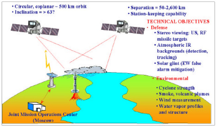
Diagram illustrating the major RAMOS system components. Click on image to enlarge.
Moving Object Experiment (MOE): The objective of this experiment was to demonstrate the ability to observe a post-boost warm body (i.e. a warm “target” after its booster had burned out) against the hard Earth background and accurately reconstruct its trajectory in three dimensions. Dedicated rocket targets would be launched from instrumented ranges in the US and Russia with the objectives met through post-flight processing of the collected data.
Multi-Spectral & Stereo Backgrounds (MSB): In this experiment, the goal was to acquire spatial and temporal radiance image databases of Earth backgrounds taken simultaneously in multiple wavelength bands. Of primary importance was the direct comparison of images acquired in the 5.4 to 7.2 μm water vapor band and the 4.23 to 4.43 μm CO2 band. These data would then be used for constructing future models as well as simulating the performance of the next generation of space-based sensors.
Background Effects of Solar Scatter (BES): The objective here was to characterize polarized solar scattering from water and ice clouds as well as investigate the multi-spectral properties of solar glints. These polarization observations would be performed primarily in the SWIR (shortwave infrared) and visible wavelengths.
Short Duration Events (SDE): Here we would perform stereo observations of short duration events at high frame rates using a range of wavelengths to demonstrate the ability of accurately locating them under a range of conditions. Short duration events would included ignition spikes from rockets as well as their subsequent burns, artillery engagements and explosions of various kinds.
Fast Changing Events (FCE): For this experiment, the goal was to demonstrate that fast changing events could be detected, observed and characterized from low Earth orbit. Primarily an environmental investigation, this included observing large fires, characterizing the extent and volume of volcanic plumes and estimating the strength of tropical cyclones.
Wind Velocity Distribution (WND): The objective of this environmental experiment was to use visible band stereo data to demonstrate the ability to determine the three-dimensional wind velocity on a worldwide basis using remote sensing data.
Water Vapor Profiles (WVP): Here the objective was to characterize the three-dimensional distribution of water vapor concentration in the lower ten kilometers of the atmosphere using SWIR and MLWIR (mid-long wave infrared) spectrometers.
RAMOS Spacecraft & Instruments
In order to meet the jointly agreed science objectives, a pair of co-orbiting satellites would be used to make the required stereo observations with a nominal 100-meter pixel footprint and with sufficiently accurate pointing information to create three dimensional reconstructions of an observed scene to an altitude accuracy of on the order of 100 meters. Originally it was envisioned that the RAMOS constellation would consist of one American and one Russian satellite with each side responsible for the instrumentation of their own satellites. But in July 2000, BMDO decided to change the architecture of the constellation to a pair of Russian-built satellites with each carrying a suite of Russian- and American-built instruments.
This change greatly complicated technical and security issues resulting from the need to comply with highly restrictive American ITAR regulations (International Traffic in Arms Regulations) in addition to usual need to protect the proprietary technology and intellectual property of the companies involved. This severely restricted the flow of technical information to the Russians and what kinds of hardware could be flown on Russian satellites launched on Russian rockets. When each country was responsible for their own satellites with joint discussions limited to more abstract technical objectives and coordinating joint operations, such issues were much less of a concern.

Diagram of the RAMOS satellite based on the Russian Yacht universal space platform. Click on image to enlarge.
In this final form, RAMOS consisted of a pair of co-orbiting spacecraft based on the Russian “Yacht” universal space platform with an estimated mass of 1,200 kilograms each. The satellites were to be launched six months apart into a high-inclination, 500-kilometer orbit from the Plesetsk Cosmodrome on separate Rokot launch vehicles. The satellites would control their orbits using onboard propulsion systems to maintain a nominal separation of 500 kilometers that could be varied from 50 to 2,600 kilometers to meet the objectives of different experiments over a range of viewing geometries. The spacecraft would have been controlled from a joint operations center located in Moscow. The minimum mission length was two years with the goal that the spacecraft could continue to function for at least five years to provide a large archive of stereo data under a wide range of conditions for future study.
The RAMOS payload sensor footprints shown in relation to each other and the available field of regard (FOR). Click on image to enlarge.
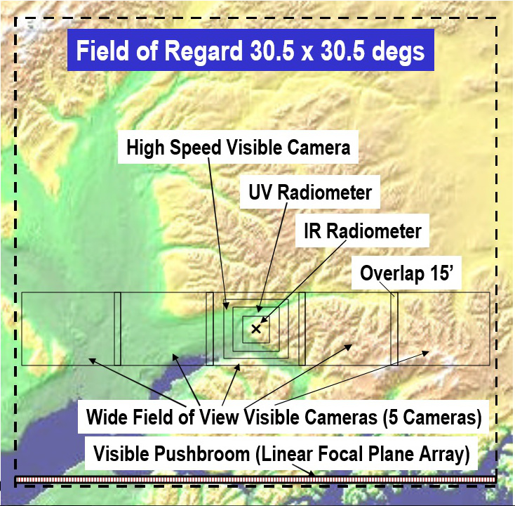
The pair of RAMOS satellites would carry nearly identical payloads of sensors primarily grouped behind two slaved pointing mirrors that moved in concert to keep the field-of-view (FOV) of the various instruments co-aligned. These pointing mirrors would allow the instruments using them to point anywhere inside a 30.5° field-of-regard (FOR) to track the region of interest and provide flexible simultaneous measurements during the course of an observation session. The whole satellite could be rotated to move this FOR over 4π steradians so that any point could be observed outside of a solar exclusion zone. The pointing system would have also been equipped with sunshades to allow observations to be made at very high scattering angles.
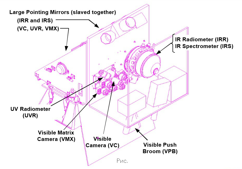
Diagram showing the configuration of the RAMOS instrument suite. Click on image to enlarge.
Infrared Radiometer & Infrared Spectrometer (IRR & IRS): Behind the first pointing mirror was the primary instrument of the payload: a two-channel IR imaging radiometer, the IRR, designed and to be built by SDL. It consisted of a pair of co-aligned 128 by 128-pixel detector arrays cooled to 77° K to improve sensitivity. The arrays would have had about a 140 μrad pixel footprint yielding a total field of view (FOV) of about 1.0°. The two arrays would allow a pair of simultaneous images to be acquired in the SWIR and MLWIR over a wavelength range from 1.5 to 7.5 μm.
The IRR packages on each RAMOS satellite were of slightly different designs. The IRR on one satellite was also designed to operate in a mode to act as a SWIR imaging polarimeter. The IRR of the other satellite also included an imaging spectrometer, the IRS, with its own pair of dedicated 128 by 128-pixel detector arrays that together covered the 2.3 to 7.5 μm spectral range using diffraction gratings. The 1° entrance slit of the IRS was offset 1° from the center of the IRR FOV. With the IRS staring in a fixed direction, the motion of the satellite would build up hyperspectral image working in a push-broom mode.

The RAMOS IR spectral bandpasses shown in comparison with the typical spectral radiances expected from Earth’s atmosphere (daytime and nighttime) and a 300 K blackbody. Click on image to enlarge. (Visidyne)
Visible Camera (VC): Behind the second mirror was a set of three Russian-built cameras. The first was a visible high-speed camera, the VC, with a 3.1° FOV operating at frame rates as high as 100 Hz. It was designed to provide visible band images of the observed scene and was capable of recording quickly changing scenes or events. The VC had a 512 by 512-pixel array with four different filters that together covered wavelengths in the 400 to 960 nm range .
Visible Matrix Camera (VMX): The second Russian instrument was a wide-field visible matrix camera system, the VMX, that used five cameras with overlapping fields to provide a total FOV of 3.5° by 30°. The VMX would be fitted with RGB filters as well as others of environmental interest that together would cover wavelengths from 460 to 960 nm. The VMX could acquire continuous image swaths to provide a regional context of what was being observed by the other instruments with narrower FOVs.
Ultraviolet Radiometer (UVR): The final Russian instrument was a multi-filtered, two-channel ultraviolet imaging radiometer, the UVR. One channel of the UVR used a 290 by 384-pixel array and would cover wavelengths ranging from 200 to 300 nm with a 1.44° by 1.92° FOV. The second channel employed a 576 by 576-pixel array that would cover from 300 to 400 nm with a 1.47° FOV.

The RAMOS UV and visible instrument spectral bandpasses shown in comparison with the typical spectral radiances expected for the sunlit clouds for two scattering angles. Click on image to enlarge. (Visidyne)
Visible Push-Broom (VPB): The final instrument was a visible-band push-broom imager, the VPB, designed and to be built by Visidyne. Unlike the other instruments that used the pair of pointing mirrors, the VPB was mounted on the spacecraft bus with a fixed 30° wide FOV aligned at the bottom edge of the FOR of the instruments using the pointing mirrors. With a cross-track pixel footprint of 64 μrad, it would use the orbital motion of the spacecraft to create its images in a push broom mode. It was designed to make measurements of polarization and cloud top altitude independently of the stereo observations (but with much less accuracy) by comparing the radiances in two selected wavelengths. This instrument also provided a wide FOV context image of the area being observed by the other instruments to complement the Russian VMX images.
RAMOS Near Term Experiments
As the design and architecture of the RAMOS constellation and its ground segment were being developed, it was decided early in the program that a series of field science campaigns would be performed to gather data on various types of cloudy scenes. The goal of these near term experiments was to develop the mechanisms needed to plan experiments, coordinate operations as well as share data and analysis results between the American and Russian teams during joint data collections. In the process, these near term experiments would acquire data needed to refine the program’s science objectives and validate performance requirements for the instruments to be carried by the RAMOS satellites. I was one of the key members of the American science team responsible for the processing and analysis of the data collected from these joint experiments including the development of the algorithms required to create three-dimensional, multispectral scene reconstructions using stereo data.
The first near term experiment campaign took place in 1995. This campaign involved the Russian Resurs-O1 satellite and the USAF/NASA ARES (Airborne Remote Earth Sensing) aircraft. The Resurs-O1 remote sensing satellite, whose design was based on the successful Russian Meteor meteorological satellite series, was equipped with a range of remote sensing instruments and was roughly analogous to the American Landsat satellites. The WB-57F ARES was a modified RB-57F strategic reconnaissance aircraft (which itself was a modified B-57 Canberra tactical bomber) designed to carry up to 1,900 kilograms of remote sensing instruments at high altitudes. For our measurement campaign, ARES carried an imaging spectrometer capable of gathering data simultaneously in 75 spectral channels from 1.9 to 6.1 μm as well as a video camera with a 6.8° FOV to provide visible-band context images.

Comparison of a mosaic of ARES video images (top) with a Resurs-O1 MSU-E image (bottom) acquired over the area of Lamont, OK on July 27, 1995. Click on image to enlarge. (A.J. LePage/Visidyne)
The first opportunity to make observations as part of this effort occurred on July 27, 1995 in the vicinity of Lamont, Oklahoma which, in addition to being known for its afternoon thunderstorms, was also the site of the highly instrumented Southern Great Plains ARM (Atmospheric Radiation Measurement) site run by the US Department of Energy which could provide vital environmental support data. Near-simultaneous observations were successfully acquired using the MSU-E push-broom visible imager and from the red-near infrared channel of the MSU-SK conical scanner of the Resurs-O1 as well as the infrared spectral imager and video camera of the ARES aircraft. While the experiment was successful in that we had started to develop the means of working together with our Russian colleagues, no clouds were visible at the time of our observations.

A comparison of a panchromatic IR image swath taken by the ARES aircraft (top) and a false color image from the MSU-E push-broom scanner on Resurs-O1 (bottom) acquired on October 5, 1995 over California’s Sierra Nevada mountains. Mt. Whitney is near the center of the ARES image swath. Click on image to enlarge. (A.J. LePage/Visidyne)
The second joint observation opportunity during the 1995 campaign took place on October 5, 1995 this time in the vicinity of Mt. Whitney in California’s Sierra Nevada range. The Russian Resurs-01 satellite successfully acquired long wave infrared (LWIR) data using its MSU-SK conical scanner and visible data using its MSU-E push-broom imager. Likewise, the American ARES aircraft successfully acquired infrared spectral imaging and visible video data from three passes over Mt. Whitney – one pass looking at nadir and a pair of subsequent side-looking passes. But once again, while the objectives relating to cooperation with our Russian partners were met, there were no clouds present in the area as had been hoped. Nonetheless, I was able to use a sequence of video images acquired by ARES to create a three-dimensional reconstruction of Mt. Whitney as a demonstration of our early stereo algorithms then under development (see “Clouds over Mt. Whitney: A 23-Year Tale of 3D Remote Sensing“).

A 3D reconstruction of Mt. Whitney based on a stereo analysis of ARES video images acquired on October 5, 1995. Click on image to enlarge. (A.J. LePage/Visidyne)
The second near term experiment campaign took place in December of 1996 this time using Russian and American satellites. Once again, the Russian Resurs-O1 satellite was employed working together with BMDO’s MSX (Midcourse Space Experiment) satellite. Because these two satellites were in near-polar, Sun-synchronous orbits with differing orientations, joint observations were only possible at high northern or southern latitudes where their orbits crossed. As luck would have it, both satellites nearly simultaneously passed over the vicinity of Mt. Erebus on Ross Island in Antarctica on December 23, 1996. While Resurs-O1 and MSX successfully carried out their observations, once again Mother Nature conspired against us and no clouds were visible in the area during the time of our experiment. Undeterred by the lack of clouds, I was able to combine data from the MSU-E push-broom imager of Resurs-O1 and the UVISI imager of MSX to create a three-dimensional reconstruction of Mt. Erebus as a further demonstration of our a stereo reconstruction algorithms.

Two views of a 3D reconstruction of Mt. Erebus in Antarctica based on a stereo analysis of visible-band images from Resurs-O1 and MSX acquired on December 23, 1996. Click on image to enlarge. (A.J. LePage/Visidyne)
In support of the conjunctive experiment with MSX, Resurs-O1 had also acquired LWIR data using its MSU-SK conical scanner in the area of Mt. Erebus on December 22, 1996 as a rehearsal of the following day’s joint observations and again on January 14, 1997 this time with plenty of clouds present. Unfortunately since neither MSX nor any other participating American spacecraft were in the area during these passes, stereo reconstructions of the clouds in these scenes was not possible. Likewise the BMDO-sponsored MSTI-3 (Miniature Sensor Technology Integration-3) satellite acquired an additional 444 images of the region at SWIR and MWIR wavelengths on March 2, 1997 as part of the campaign.

A false-color SWIR-MWIR mosaic of the area around Mt. Erebus constructed using images from MSTI-3 acquired on March 2, 1997. In this view, clouds and the open water are blue, bare ground is white and snow-covered areas are various shades of brown. Click on image to enlarge. (A.J. LePage/Visidyne)
The next phase of the near term experiments shifted from aircraft and satellite-based conjunctive experiments to a field measurement campaign designed to gather data in support of refining the RAMOS instrument requirements. For this phase, the FISTA (Flying Infrared Signatures Technology Aircraft) was employed to gather polarization measurements in the infrared in an effort to validate the models members of our science team were developing to predict the polarization properties of light reflected from water and ice clouds.

The FISTA aircraft (a modified USAF NKC-135E aerial refueling tanker) used for the RAMOS near term experiment campaigns in 1997, 1998 and 1999.
The FISTA aircraft (which was actually the second used in this long-running program) was a USAF NKC-135E aerial refueling tanker that had been modified in 1995 to act also as an instrument platform to gather data in support of various Defense Department research programs. For the 1997 campaign, FISTA was equipped with several instruments that had been modified to obtain polarization measurements at various infrared wavelengths. First was a trio of Michelson interferometers supplied by AFRL (Air Force Research Laboratory) to gather data in the 1.5 to 7.0 μm range of the infrared including the water absorption bands that were of the greatest interest to RAMOS. SAIRS (Schottky Array Infrared Sensor), also supplied by AFRL, was an infrared imager modified to obtain polarization images at wavelengths of 2.33 to 2.65 μm. Next was MAVIS (Multispectral Airborne Video Imaging System) built by Visidyne to obtain visible light context images and modified to provide polarization measurements for us. The last instrument was PEELS (Portable Eyesafe Environmental Lidar System), also built by Visidyne, to obtain information on the altitude of the clouds being observed by the other instruments as well as help determine whether they were composed of water or ice.
The first group of three flights took place in July of 1997 with another three flights taking place the following September. All together, about 16 hours of useful polarization data were gathered of cloud fields over various locations of the western US including observations of solar glints on clouds. These data largely agreed with our model results and allowed us to refine them further to provide better predictions of what would be observed from real clouds. Also noted was the wide variability of the scattering environment even in apparently featureless decks of clouds.

A comparison of visible band total intensity (left) and degree of polarization (right) images acquired by MAVIS during the September 18, 1997 FISTA flight. The dark smudge on the right side of the intensity image is an instrument artifact but note how this nearly featureless cloud deck shows a wide range of polarization. Click on image to enlarge. (A.J. LePage/Visidyne)
Building on our experience from our 1997 campaign with FISTA, we altered the mix of polarization instrumentation for a follow up campaign in 1998. Among the new instruments was HIP (Hyperspectral Imaging Polarimeter) built by SDL to gather infrared polarization data in the 2.5 to 3.5 μm spectral range. In addition, we also added the Aquameter Water Band Radiometer. The Aquameter was a scanning radiometer built by our Russian partners at the Vavilov State Optical Institute in St. Petersburg, Russsia that gathered data simultaneously in forward- and back-looking directions in four infrared bands from 4.6 to 7.2 μm . The purpose of this instrument was to gather pseudo-stereo imaging data in or near various water absorption bands to characterize the structure of clouds at pixel footprints of a few to a few tens of meters (depending on the altitude of the observed clouds relative to the FISTA aircraft) in order to help the science team refine the choice of filter bands to be used on the RAMOS IR imaging radiometer.

A comparison of Aquameter images in the 5.4 to 7.2 um band (top) and 4.6 to 4.9 um band (middle) with a cloud altitude trace derived from PEELS lidar data (bottom). These cloud data (with the cold clouds appearing dark against the warm atmosphere below) were acquired during the FISTA flight on October 1, 1998 (UT). Click on image to enlarge. (A.J. LePage/Visidyne)
A total of six flights were made in late September to early October 1998 over various locations in the southwestern US as well as off the Pacific coast of California. The first three flights were dedicated primarily to obtaining polarization measurements in a continuation of our 1997 measurement campaign. The final three flights emphasized measurements using the Russian-built Aquameter. These six flights gathered a huge volume of data including around a dozen hours of Aquameter data that helped us further refine our models and the design requirements for the RAMOS instruments. One of the unexpected discoveries from our flights was the observation of tropospheric waves in the cloudless atmosphere in some of the Aquameter water-band images. While waves with scales on the order of ten kilometers had been observed by us and others in association with mountainous terrain and were orographic in origin, we had also recorded much smaller scale clear air waves with wavelengths on the order of a few hundred meters which had apparently never been observed before.

A calibrated Aquameter image acquired during the FISTA flight on September 30, 1998 (October 1 UT) in the 5.4 to 7.2 um water band that has been filtered and geometrically processed to correct for the instrument’s circular scan pattern. The observations of clear air waves with a scale length of a few hundred meters visible in this 15-km long image is considered unique. The faint, circular arcs visible in the image are instrument artifacts distorted by the processing. Click on image to enlarge. (A.J. LePage/Visidyne)
A final FISTA measurement campaign in support of RAMOS was flown in December 1999. These flights used essentially the same mix of instruments flown in 1998 with some modifications made to improve instrument performance. While three of these flights had the Aquameter operating in a nadir-viewing mode as had been done during the 1998 campaign, for the remaining three flights, the center of the Aquameter’s scan pattern was canted forward to provide imaging data at higher nadir angles in support of RAMOS science objectives. Once again, all six flights were successful in gathering huge amounts of additional polarization and IR radiance data including over 18 hours of useful Aquameter data. With these data in hand, the near term experiments of the RAMOS program were ended.
The End
I will have to leave a full and accurate accounting of the political and bureaucratic machinations that led to the eventual cancellation of RAMOS for a later time. However, from my perspective as a member of the US science team, I knew that the program was suffering from a series of problems unique to this endeavor. In addition to what was felt to be a pattern of chronic underfunding and the constant threat of cancellation (which was hardly unique to this particular space project), there was the simple fact that BMDO (and later, MDA) was institutionally ill-suited to carry out this kind of research and development project. Unlike the earliest days of BMDO and especially its predecessor, SDIO (the Strategic Defense Initiative Organization which ran America’s “Star Wars” program in the 1980s), by the late-1990s BMDO had largely gotten out of the business of performing pure R&D and had been transformed into an agency concerned with the acquisition of systems from contractors. The “square peg” of a cooperative international R&D program like RAMOS just did not fit conveniently into the “round hole” of an acquisition-oriented government bureaucracy.
These problems were further exacerbated by stark differences between how American and Russian space programs were run – a problem that caused me many sleepless nights when I was responsible for the effort of negotiating hardware requirements with Russian engineers especially after the architecture of the RAMOS constellation was changed in 2000 to a pair of Russian-built satellites. In an American program, the science objectives are set, system performance requirements are then formulated to meet those objectives and finally hardware specifications are derived to meet those performance requirements with the engineers building to those specifications.

This pair of photos was taken during a break in system requirements negotiations with the Russian engineering team as part of a joint meeting at Astrophysica in April 2002. In the left panel are some members of the US science team (left to right): Jay Jordano (Visidyne), A.T. Stair (President, Visidyne), the author (Andrew LePage, Visidyne), John Watson (Aerospace) and Ilya Schiller (Visidyne). In the right panel, the author tries to figure out our next step. Click on image to enlarge. (A.J. LePage)
The Russians practiced a different philosophy that in some ways turned this process on its head. With a broad understanding of the ultimate scientific goals of a program, Russian engineers would design and build the best hardware that they can with the technology and resources they have available leaving the scientists to do the best they can with what the engineers actually built. While it was a relatively straightforward process to get agreement with Russian engineers on requirements that could be readily met, it became increasingly difficult to get agreement on the more difficult requirements needed to meet the agreed science objectives. Fold in the limitations and extra layers of bureaucracy required to conform with highly restrictive American ITAR regulations and just the process of setting system requirements literally dragged on for years longer than it normally should have.
While there were a host of diplomatic, political and bureaucratic issues that plagued forward progress of the program in the upper echelons of the American and Russian governments, there were also a series of missteps that strained the relationship of trust that had developed between the Russian and American teams over the years. One of the more serious ones was in 2001 with the unexpected insertion of a new player into the program: a team of talented engineers and managers from Ball Aerospace in Boulder, Colorado who provided an additional layer of oversight of the program for BMDO. While BMDO was footing the bill for the entire program and felt it required an independent set of eyes to look out for its interests, the Russians were wary of the introduction of these “strangers” into the program and the additional layer of oversight further slowed progress.

A portrait of the RAMOS team in attendance at a joint Russian-American meeting at Aerospace Corp. in El Segundo, CA in March 2002 as we were preparing for PDR. Click on image to enlarge. (Aerospace)
Despite the problems and delays along with escalating costs and a slipping launch date, the RAMOS program was making progress. The PDR (Preliminary Design Review) for the American instrument payload was successfully completed in May 2002 followed by the joint PDR with our Russian partners for the space and ground segments in June 2003. As we were pushing forward towards CDR (Critical Design Review) and launch by about 2009, we got word about the cancellation of the RAMOS program in the worse possible way.
On the morning February 6, 2004 while we were conducting a joint meeting with our Russian partners at SDL in Logan, Utah, we got word via a press release that Secretary of Defense Donald Rumsfeld had withdrawn funding for the RAMOS program in his FY2005 defense budget and that MDA was unilaterally cancelling the program without consultation with our Russian partners after a dozen years of effort and the expenditure of $120 million. The reason for the cancellation given in the press release was that MDA had concerns about the future of the RAMOS program. The basis of these concerns included the program delays and the lack of a government-to-government agreement that explicitly covered the latest incarnation of the RAMOS constellation – issues, it could be argued, that were largely of MDA’s own making. The press release went on to state that it was felt that the estimated $550 million needed to complete the program could be better spent on other cooperative missile defense projects with Russia.
In July 2004, MDA issued a notice for the immediate termination of the RAMOS contract and rescinded funds already obligated for the balance of FY2004. Despite the best efforts of supporters of the RAMOS program in Congress to reinstate funding for FY2005 as well as the valiant attempts by the managers at the various American contractors to reinstate the already obligated FY2004 funds and stretch them out in order to keep the teams together for as long as possible, RAMOS officially ceased to be on September 15, 2004. While attempts were made to revive RAMOS or some other replacement project in the following years, there was simply insufficient support in the Administration or Congress to do so. And despite the claim of the Bush Administration that the savings from the cancellation of RAMOS would be used to fund new cooperative missile defense projects with Russia, none ever materialized.
Since the cancellation of RAMOS, the American engineering and science teams have dispersed to work on other projects and, in most cases, for other employers. In addition, a large number of its most experienced team members including many of those responsible for creating the program to begin with, have long since retired. Work on some of the RAMOS-related experiments continued in various forms including, most recently, the proposed Visidyne CyMISS (Cyclone Intensity Measurements from the ISS) project to measure the strength of tropical cyclones using remote sensing data – a revival of the science originally developed as part of the Fast Changing Events experiment of the RAMOS program. While it is too late to revive RAMOS, only time will tell if there will ever be another cooperative defense program between the US and Russia like it.
Disclaimer
This article was prepared using information available from public-domain sources including conference proceedings prepared by various RAMOS team members that had been previously cleared by the appropriate agencies of the US Federal government for public release. Views and opinions expressed in this article are solely those of the author and do not represent the official positions of any organization or company, including the author’s employer, Visidyne, Inc..
Follow Drew Ex Machina on Facebook.
Related Reading
“Memories of Project RAMOS (Russian American Observation Satellites) 1991 – 2004”, Drew Ex Machina, September 29, 2023 [Post]
“Clouds over Mt. Whitney: A 23-Year Tale of 3D Remote Sensing”, Drew Ex Machina, November 28, 2018 [Post]
“A New Satellite-Based Method to Determine the Strength of Hurricanes” Drew Ex Machina, June 18, 2014 [Post]
General References
Cynthia J. Beeler, Charles H. Humphrey, Andrew J. LePage, Mary E. Pitkanen, Orr Shepherd, and Barry Tilton, “RAMOS Near Term Observations”, Proceedings from 1996 IEEE Aerospace Applications Conference (Aspen, CO; February 3-10, 1996), Volume 3, pp. 75-88, 1996 [Paper]
C.J. Beeler, S.A. Rappaport, P.C. Joss, M.E. Pitkanen, A.J. LePage, A.T. Stair, Jr., M. Greenman, G. Jensen, J.A. Kristl, and J. Peterson, “Hyperspectral Imaging Polarimeter (HIP) Observations of Ice Clouds: Data and Modeling”, Proceedings of 2000 IEEE Aerospace Conference (Big Sky, MT; March 18-25, 2000), 2000 [Abstract]
W.A. Blumberg, J. Shanks, A.J. LePage, and A.T. Stair, “Spatial Structure in Clear-Air Water Vapor”, Proceedings of American Geophysical Union Fall Meeting 2003 (San Francisco, CA; December 8-12, 2003), 2003 [Abstract]
R. Cargill Hall, “Missile Defense Alarm: The Genesis of the Space-Based Infrared Early Warning”, Quest, Vol. 7, No. 1, pp. 5-17, Spring 1999
Marsha Freeman, “The Long Road To US-Russian Missile Defense Cooperation”, Executive Intelligence Review, Vol. 34, No. 28, pp. 9-11, July 20, 2007 [Article]
T. Humphreys, A.T. Stair, V. Sinelshchikov and V. Abramov, “Environmental Objectives for the Russian American Observational Satellites (RAMOS) Program”, Proceedings of SPIE Conference on the Remote Sensing of the Atmosphere, Ocean, Environment and Space [Hangzhou, China; October 23-27, 2002], 2002 [Paper & Presentation]
T. Humphreys, V. Privalsky, V. Sinelshchikov, V. Abramov, V. Misnik, A.T. Stair and I. Schiller, “Defense and Environmental Objectives for the Russian American Observational Satellites (RAMOS) Program”, Proceedings of 18th Annual AIAA/USU Conference on Small Satellites [Logan, UT; August 2004], SSC04-I-7, 2004 [Paper]
A.J. LePage, A.T. Stair, R.J. Jordano, P.C. Joss, J. Devore, J. Kristl, B. Sanford, and J. Schummers, “IR/Visible Polarization Measurements of Scattered Solar Radiation from Clouds”, Proceedings of 1999 IEEE Aerospace Conference (Aspen, CO; March 6-13, 1999), 1999 [Paper]
Andrew J. LePage, “The Promise of MIDAS”, Space Views, February 21, 2000 [Article]
A.J. LePage, A.T. Stair, A.P. Savin, and V.F. Zakharenkov, “Atmospheric Observations Made Using the Aquameter Water Band Radiometer”, Proceedings of 2000 IEEE Aerospace Conference (Big Sky, MT; March 18-25, 2000), 2000 [Paper]
Jeffrey T. Richelson, “Space-Based Early Warning: From MIDAS to DSP to SBIRS”, National Security Archive Electronic Briefing Book No. 235, The George Washington University, posted November 9, 2007 [Link]
Victoria Samson, “Prospects for Russian-American Missile Defense Cooperation: Lessons from RAMOS and JDEC”, Contemporary Security Policy, Vol. 28, No. 3, pp. 494-512, December 2007
A.T. Stair, V. Abramov, A. Sidorin, T. Stephens, J.W. Carpenter, A.J. LePage, V. Sinelshchikov, T. Humpherys, and P. Gretzkowski, “RAMOS (Russian American Observation Satellites) Experiments to Obtain a Three Dimensional Background Data Base” , Proceedings of 2003 Multinational BMD Conference (Kyoto, Japan; June 9-12, 2003), 2003 [Paper]
N.W. Watkins, “The MIDAS Project: Part I Strategic and Technical Origins and Political Evolution 1955-1963”, Journal of the British Interplanetary Society, Vol. 50, No. 6, pp. 215-224, June 1997
“BMDO Fact Sheet: Russian-American Observation Satellite”, BMDO Fact Sheet 305-00-11, November 2000 [Link]
“MDA Fact Sheet: Sensors”, MDA, January 2002 [Link]
“Missile Defense Agency Fiscal Year (FY) 2005 Budget Estimates”, MDA, February 18, 2004 (for “Change 1”) [Press Release]